Saving freshwater
Microsatellites against water wastage
Researchers from Freiburg want to limit water wastage in agriculture with a swarm of microsatellites.
They are the size of shoe boxes and collect data on the temperature at the earth's surface. That helps estimate water needs, says Marius Bierdel, CTO of ConstellR: "When plants are in bad shape, they turn brownish and wilt. But then it's too late." Thanks to the infrared technology with which the microsatellites of the Freiburg-based startup ConstellR are equipped, it should be possible to see two weeks earlier where there is a need to water. On the other hand, wasting water in other places can be prevented, Bierdel says. ConstellR is a spin-off of the Fraunhofer Institute for High-Speed Dynamics (EMI) in Freiburg, which led the project.
400 times less cost, under 100 m resolution
But aren't existing weather satellites already collecting the necessary data? That's true, but these satellites are the size of a bus and cost as much as 800 million euros. So there are only a few of them - and they only sweep a particular farmer's land once every few weeks. "But breaking the data down to the fields of individual farmers is critical for agriculture," Bierderl explains. That's exactly what ConstellR's new technology is suited for: via the shoebox-sized satellites, costs are reduced by a factor of 400 and resolution improves to less than 100 meters.

Space test on the ISS
To test the technology - primarily a reflecting telescope with a thermal infrared camera and a miniaturized computer for data processing - in advance, a prototype of the measuring instrument is to be sent to the ISS space station on Feb. 19. Only in a further step will it address satellite-specific issues such as power supply, communication and positioning in a specific orbit. "That's a lot of construction sites that have nothing to do with core technology for the time being," Bierdel explains.
By the end of 2024, the first four ConstellR satellites should be in space, according to the plan: "With that, we can already cover 10 percent of the world's agricultural land."
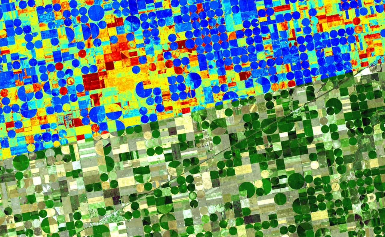
The result of the measurements will be heat maps, maps full of colorful dots. Specialist companies are then to analyze the data. They could find application not only in agriculture, Bierdel hopes. "They could also make weather models more accurate, help with urban planning or drive more effective disaster management."

Today, most water is wasted
Agriculture uses 70 percent of the world's accessible freshwater, according to the environmental organization WWF. However, leaky irrigation systems, inefficient application methods, and crops that require too much water relative to their environment mean that 60 percent of it is wasted. Similar figures are cited by the Food and Agriculture Organization of the United Nations (FAO) and a study by the Potsdam Institute for Climate Impact Research and Humboldt University in Berlin, among others.
German Farmers' Association shows great interest
This is where Bierdel and his team come in: They want to make their data available primarily to companies that analyze agricultural data and pass on the findings to their customers. The German Farmers' Association (Deutscher Bauernverband) clearly shows that there is interest in the project. According to a spokeswoman, there is great hope that satellite-based measuring instruments such as the one developed will help farmers to manage water resources more sustainably. "However, we assume that this technology can be used for more than just irrigation or soil moisture measurement." The most important application for satellite data, she said, is GPS services for more precise and targeted application of fertilizers and crop protection products.
Earth observation from space is nothing new in itself. The German Space Agency at the German Aerospace Center (DLR) lists a whole series of ongoing and completed projects. Space agency expert Michael Nyenhuis sees commercial projects as complementary to government-funded ones, which provide coarser data and are usually used in less specific ways.


